
The Public Sector Geospatial Agreement has transformed access to Britain’s national location data. We look at what GDS, Ordnance Survey and public-sector users have achieved together, how organisations are using the data and how the next phase can build on that progress.
Britain’s national location data has taken a significant step forward.The OS National Geographic Database (OS NGD) now contains 16 data collections and has received 70 major enhancements since its launch in 2022. Together, they form the most detailed and data-rich digital map of Britain produced by Ordnance Survey (OS).
This is a significant milestone for the Public Sector Geospatial Agreement (PSGA), which GDS manages on behalf of government in partnership with OS. It also provides a strong foundation for the next phase of our work.
Our emerging ambition is to build on the current agreement and develop a broader strategic partnership with OS. We want trusted, high-quality location data to reach more public services, digital platforms and users, while supporting innovation, the responsible use of data and AI, and economic growth.
Delivering better data through partnership
The PSGA was launched in 2020, providing a common framework through which eligible public-sector organisations can access OS data and expertise.
It has delivered more than access to established mapping products. The agreement has supported a wider transformation in how Britain’s national location data is structured, accessed and used.
One of its most significant achievements has been the launch and development of the OS National Geographic Database. The OS NGD brings authoritative and detailed geographic data about Great Britain together in one place.
Its latest release includes:
- complete coverage of bus and cycle lanes across Great Britain
- improved postcode information aligned with real-world features
- a new geographical view of retail areas
Users can access OS NGD data through application programming interfaces and OS Select+Build, which allows organisations to create customised datasets.
These improvements give public bodies a stronger foundation for planning services, understanding communities and making better-informed decisions.
They are the result of sustained collaboration. GDS provides strategic oversight of the agreement, helping to ensure that investment reflects government and public-sector priorities. OS captures, maintains and improves Britain’s national location data, while feedback from users helps identify where further improvements could deliver the greatest value.
Putting the data to work
Around 6,500 public-sector organisations across England, Scotland and Wales currently access authoritative OS data and expertise through the PSGA. The value of the agreement can already be seen in how organisations are using the data.
Newark and Sherwood District Council has adopted the full range of OS NGD products and integrated the data into its systems. This has strengthened its geospatial capability and supported work including safer walking routes, planning CCTV locations and analysing access to local health services.
Torfaen County Borough Council has combined roads, water, land-cover and sites data to create a more detailed view of its green infrastructure. This supports public engagement, planning decisions, contract tenders and the future maintenance of parks, paths and blue spaces.
OS data has also supported a tool developed with Transport for the North to help local authorities understand regional differences in access to electric vehicle charging infrastructure. Using machine learning, the tool identifies which of the region’s 6.4 million households are likely to have access to off-street parking and therefore the potential to charge an electric vehicle at home.
These examples show how trusted national data can be combined with local knowledge and new technology to address practical public-policy challenges.
David Ball, Head of Public Sector at Ordnance Survey, said:
“The delivery of the PSGA to date has been a real success story for the public sector and for users of authoritative location data across Britain. Working closely with GDS, we have strengthened access to the data, expertise and services that organisations need to make better decisions and deliver better outcomes.
“The continued development of the OS National Geographic Database is a clear example of that progress, bringing richer, more detailed and more accessible location data together in one place, and helping public-sector organisations turn trusted geospatial information into practical impact.”
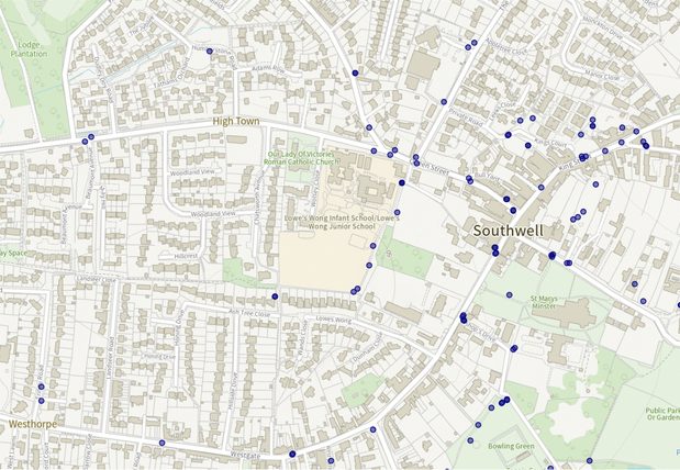
Mapping of Southwell town centre and surrounding residential streets showing the locations of litter bins as blue circular markers - helping keep the area clean and tidy.
Supporting growth and the UK’s data economy
The UK is home to a world-leading geospatial ecosystem. Our collaboration with OS through the PSGA is helping to ensure that this strength delivers real benefits for citizens, public services and the economy.
By improving access to high-quality location data, the PSGA is enabling innovation, supporting the responsible use of data and AI, and creating foundations for future growth across sectors.
An independent Economic Impact Report commissioned by OS estimates that every £1 of public funding invested in OS generates £9.50 in societal benefit. It estimates an economic impact of more than £10 billion over 10 years, equivalent to around £1 billion each year across a wide range of sectors.
Building the next phase of the PSGA
The PSGA has created a strong national data foundation. Our focus now is on increasing the value and impact generated from it.
The next phase will build on what has worked while responding to changing technology, user needs and government priorities. It provides an opportunity to broaden access to trusted location data, make it easier to use and help more organisations apply it to public services and wider economic challenges.
This supports the ambition set out in GDS’s roadmap for modern digital government, which explains how the public sector is using technology to make government work better for the citizens it serves. Trusted location data forms part of the digital public infrastructure needed to connect services, support responsible use of AI and make better-informed decisions.
Work under the current agreement will continue alongside planning for the future. GDS and OS will help organisations adopt OS NGD data and move from longstanding products to newer OS NGD-derived services. We will also continue listening to users and learning from their experiences.
The PSGA has demonstrated the value of investing in better data. The next phase is about ensuring that data reaches more users and delivers even greater impact for people, places and the economy.
Help shape the future of location data services
GDS is undertaking engagement across the public sector to understand emerging challenges and opportunities that will shape the future iteration of the PSGA. If you haven't already done so, take this opportunity to provide your input and complete GDS's survey.
Find out more about PSGA at the PSGA autumn 2026 events register for a free place at one of the national or regional events.
Read about the latest OS National Geographic Database release and data enhancements.
Find out how public-sector organisations can access OS data through the Public Sector Geospatial Agreement.
You can sign up to get an email notification every time we publish a new blog post. For more information on our work see the GDS gov.uk site, or follow us on LinkedIn
Leave a comment